Porcupine Rim Whole Enchilada Moab – Mountain Biking Trail Analysis For Intermediates
These are the lower trails of The Whole Enchilada ride
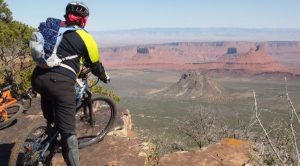
I analyze the Kokopelli, UPS (Upper Porcupine Singletrack), LPS (Lower Porcupine Singletrack), and Porcupine Rim trails for 18 miles from the shuttle drop-off at the top of Kokopelli to the Colorado River. Along the way you will encounter the La Sal Mountains in their winter clothing, the big views from the edge of Porcupine Rim over Castle Valley, and riding the exciting and challenging cliffs above the Colorado. Ride with us as we explore this amazing and beautiful trail system!The purpose of this video is to inform intermediate mountain bikers about the tread conditions so they can decide if they want to try one of the most famous mountain bike rides in the world.
This trail analysis includes most of the Whole Enchilada trail series. Burro Pass and Hazard County trails are above Kokopelli but were still blocked by snow on May 5, 2013 when we rode it. We were dropped off at 8 AM at 8,300 feet and it was damn cold when our bikes picked up speed. Even with bike gloves we had to stop and thaw our fingers several times.
The ride took us 6 hours including shooting video, a long lunch break, and enjoying the views. You can bomb it in a lot less time if that is the goal. It is easy to beat your bike up on these trails, not hard to end up in the emergency room, and it is moderately physically challenging although it is almost entirely downhill. However, the vast majority of the trail can easily be rode by intermediate riders. Don’t be ashamed to get off and hike the bike. We did and we saw many others being careful not to get hurt.
It took longer to select the music for this video than the entire ride. Hope you like my selection.
Ride stats: Max elevation 8,334 feet, 1,410 feet elevation gain, 4,400 elevation loss. No significant climbs. Garmin 60 CSX. Cannondale Rush, Cannondale Jekyl.